MAPS Artistic Cartography in the Centre of Europe 1960 - 2011
MAPY / MAPS I. Známe a neznáme / Known and Unknown
30.06.2011 - 28.08.2011 | Bratislava City Gallery
MAPY / MAPS II. Neznáme oblasti / Unknown Areas
14.06.2011 - 03. 09. 2011 Slovak National Gallery, Water Barraks, Cabinet of the 20. Century Art+
Curators: Daniela Čarná, Lucia Gregorová
Galéria mesta Bratislavy I Bratislava City Gallery
Mirbach palace
Františkánske nám. 11
815 35 Bratislava
Tel: 02/ 5443 2807
http://www.gmb.bratislava.sk/en/home
International exhibition project MAPY / MAPS explores art cartography from the 1960’s to today. The exhibition presents not only known, but also lesser known and never before displayed works by artists active in the 1960’s and 1970’s in the areas of conceptual art and land-art, in the 1980’s also in painting and photography, while the 1990s are reflected through neo-conceptual objects and installations. Selected works created by the youngest generation of artists often use maps and principles of mapping, networks, roads, thinking and research with the help of map as a metaphor for the very creation of their artwork. Over the past 50 years, map has become an important vehicle in art for sharing cultural meaning as a medium of utopian visions, mental archaeology, futuristic projects or even as a projection of territorial or political frustrations. The exhibition argues that in contemporary art, maps serve also as a reflection of discourse about the geopolitical space of Central Europe. In this art-historical sample, the exhibition follows “on the map” of works by more than 50 artists’ relationship to everyday reality, starting with the intersection of art and life in neo-avant-garde tendencies of the 1960s up to the forthright manifestation of life in art enabled by the new media.
The exhibition focuses on “mapping” interpretations and reflections of maps in the Slovak art scene in the juxtaposition of selected works by key artists in the Visegrad countries area: Czech Republic, Poland and Hungary. While it is composed chronologically, it also allows a layered reading through several themes present throughout the exhibition. Based on the exhibited material, we can trace ways of artistic thinking about borders, their limitations, forms of their free virtual crossing or re-defining in utopian projects, as well as through mental shifts in their transfer, scale changes or changes in positions of states and continents. They capture experience from a physical presence in the landscape and orientation in urban or natural terrain; on a metaphorical level, they portray subjective individual mythologies and the search for a lost paradise, mythical and newly discovered countries, or a shift to transcendency of cosmic space(s). Another layer of reading is provided by the catalog, designed as an atlas of artistic maps, which is accompanied by references to the rich field of critical reading of maps.
Exhibition MAPY / MAPS does not offer a simple orientation to the terrain of art. It invites the viewer to enter new worlds and through various strategies of using maps in art.
Artists: Milan Adamčiak, Gábor Attalai (H), Peter Bartoš, Juraj Bartusz, Erik Binder, Bálint Bori (H), Vladimír Boudník (CZ), David Černý (CZ), Anna Daučíková, Jiří David (CZ), Martin Derner, Ľubomír Ďurček, Stano Filko, Daniel Fischer, Juraj Gábor, György Galántai (H), IPUT / Tamás St.Ruby (H), Jozef Jankovič, Peter Kalmus, Michal Kern, Július Koller, Patrik Kovačovský, Marek Kvetán, Barbara Kozłowska (PL), Jarosław Kozłowski (PL), Otis Laubert, Lengow&Hermes, Milan Maur (CZ), Juraj Meliš, Milan Mikula, Svätopluk Mikyta, Alex Mlynárčik, Michal Murin, Ilona Németh, Miloš Novák, Boris Ondreička, Eduard Ovčáček (CZ), Štefan Papčo, Jan Pfeiffer (CZ), Sándor Pinczehelyi (H), Ludmiła Popiel (PL), Jerzy Rosołowicz (PL), Rudolf Sikora, Tomasz Sikorski (PL), Magda Stanová, Miloš Šejn, Dezider Tóth, Jaro Varga, Kamil Varga, Włodzimierz Jan Zakrzewski (PL)
Works of Milos Sejn:
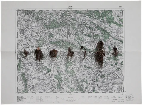
Valeriana Roots, 14th July 1960
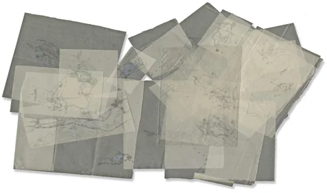
Cartography Studies, 1969
PEDESTRIAN MAPS
Miloš Šejn documents his trips into nature (and his attemps to unite with nature and react to its genius loci - "becoming a landscape") in various ways - from photo-documented performances to collecting and categorizing various natural materials. A map is a logical element here. In his work Roots of Valerian (1960), that implies a reference to discoveries and that fascination with nature typical of a child, he ritualistically placed roots of a medicinal plant used for insomnia on the top of a real map of Jičín.
In his journal entry-like Cartographic Studies (1969), he records his exploration of a landscape terrain into his own maps by layering and overlapping on transparencies,, while, in a spirit of Borghes' map, the scale used here is 1 : 1. In 1992 in collaboration with the Dutch choreographer Frank van de Ven, Miloš Šejn created project Bohemiae Rosa. In focuses on strengthening the relationship between body and landscape. Its title derives from the map created by carto-grapher Christoph Vetter for the historical opus by Bohuslav Balbín (1668). It bears the curious shape of a blooming rose growing from Vienna, which symbolizes the blossoming of a land.
Ectract from MAPS / Known and Unknown by Daniela Čarná and Lucia Gregorová, Bratislava 2011